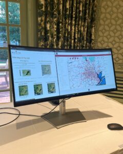
The West Houston Association (WHA) Map App, developed by BGE, is a cutting-edge tool designed to improve understanding of the Greater West Houston region’s growth, infrastructure, and development opportunities.

Building on the history of WHA’s Development Maps, which dates back to 1979, the Map App modernizes this concept by offering real-time updates on land use, infrastructure, and development projects. Historically updated every three years, the new Map App technology enhances this frequency, updating some features annually and others even more frequently through data pulled from various sources. The Map App supports WHA’s mission of promoting responsible and strategic development to improve the quality of life in the greater West Houston region and beyond.
The Map App provides a comprehensive, interactive platform that highlights key development projects, infrastructure improvements, and geographic features in the Greater West Houston area. The app integrates data from multiple sources to give users an up-to-date view of ongoing and planned projects, such as residential communities, commercial developments, transportation improvements, and projects that have received special recognition or awards from WHA. This tool is particularly valuable to land developers, urban planners, civil engineers, and public officials who need a broad perspective on how these projects fit into long-term regional goals like those outlined in WHA’s 2060 Plan.
One of the app’s standout features is its layered mapping capabilities, which allow users to toggle between different infrastructure elements such as roadways, flood control systems, and green spaces. This functionality is crucial for professionals needing focused information on specific aspects of regional planning, such as transportation networks or water management systems. The Map App also integrates geospatial data, offering insights into physical characteristics like floodplains and drainage basins, helping developers plan more resilient projects in areas prone to natural challenges like flooding.
A key strength of the app is its ability to provide near real-time updates on infrastructure projects, keeping users informed as new developments are initiated or progress. This is especially valuable for ensuring that West

Houston’s rapid growth is managed strategically. As the region expands, particularly in areas like Harris, Fort Bend, and Waller counties, the Map App helps align individual projects with broader regional plans, emphasizing
sustainable infrastructure, improved mobility, and water resource management.
Overall, the WHA Map App plays a critical role in regional planning by facilitating better collaboration among stakeholders. Local governments, private developers, and engineers can all use the app to coordinate more effectively, ensuring that growth across West Houston is sustainable and aligned with long-term goals. By centralizing information about development and infrastructure projects, the app supports improved decision-making, collaboration, and planning, helping the region continue to thrive as a vibrant, sustainable, and resilient community.
