Harris County Adopts New Development Regulations Based on Atlas 14 Data
Last week, the Harris County Commissioners Court adopted changes to development regulations that were based on the updated Atlas 14 study of historical rainfall data. These changes are effective immediately. Atlas 14 is a study conducted by the National Oceanic and Atmospheric Administration (NOAA) to analyze rainfall data in order to revise rainfall amounts that define 100-year storm events. These events are those that on average occur every 100 years or have a one percent chance of happening in any given year and provide the primary data for mapping floodplains and establishing our Flood Insurance Rate Maps (FIRMs).
The Atlas 14 data showed that rainfall totals for a 100-year event over 24 hour period went from 13 inches to roughly 18 inches in our region. These estimates make the presumed 100-year event when the new maps are drawn equivalent to today’s 500-year event.
Using this new data, the Harris County Flood Control District (HCFCD) and the Harris County Engineering Department (HCED) developed and proposed revisions to their development regulations, specifically, the HCFCD Policy Procedure & Criteria Manual (PCPM) and the HCED Regulations for Floodplain Management and Regulations for the Approval and Acceptance of Infrastructure.
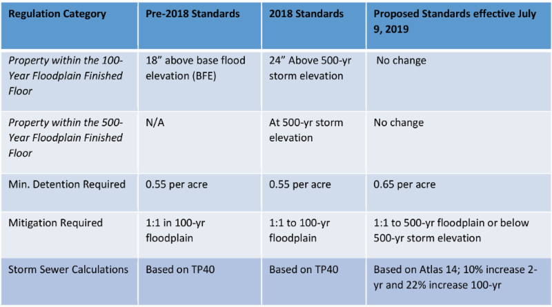
What has changed?
This is a box that shows the high level changes that have been adopted.

Although these are effective immediately, there are vested rights contingencies and definitions for projects that are in the application process or are already existing.
In accordance with Texas Local Government Code Chapter 245, the following projects are not subject to review under these Interim Guidelines and Criteria.
- Projects with a completed or unexpired administratively complete application for Preliminary Plat (not including General Plans) to Harris County or a municipality on or before midnight of the effective date of these Interim Guidelines and Criteria, provided that the project is not substantially modified.
- Projects with an administratively complete development permit application submitted to Harris County on or before midnight of the effective date of these Interim Guidelines and Criteria, provided that the project is not substantially modified.
- Projects with an administratively complete drainage report submittal or plan submitted to Harris County or the District, or projects with an Interpose No Objection (INO) letter from the District issued on or before midnight of the effective date of these Interim Guidelines and Criteria, provided that the project is not substantially modified.
• Dormant projects as defined under Texas Local Government Code Section 245.005 are subject to review under these Interim Guidelines and Criteria.
• Substantially modified means changes to the approved plans or drainage report that will increase impervious cover, or the volume and/or peak discharge of the stormwater runoff from portions of, or the whole of the project, or any other change that would affect the volume or peak discharge of stormwater runoff that would cause adverse impacts to offsite properties.
For More Information:
In addition, HCFCD and HCED are holding an Atlas 14 Implementation Training on Regulation and Criteria Changes on Tuesday, July 23 from 9 a.m. to 12:00 p.m. at the Houston TranStar Conference Center – 6922 Katy Rd, Houston, TX 77024.
We have attached the pertinent documents from both Harris County Flood Control District and Harris County Engineering. If you have any questions or would like more information, please contact GHBA Government Affairs Director Bradley Pepper at bpepper@ghba.org or 281-664-1430.
1-HCFCD PCPM Atlas 14 Guidelines Cover Memo_Final
